Only 29.2% of the surface of Earth is land, while the remaining 70.8% is covered by the oceans. The landmasses located above sea level are divided into continents. While there are various ways to distinguish the continents, the most common model counts seven of them: Europe, Asia, Africa, North America, South America, Australia, and Antarctica.
Furthermore, there are many outlying islands that are not part of these landmasses but are sometimes grouped along with the nearest continent, if they are within the continental shelf of an adjacent continent. Other pieces of continents that broke off and are now separated from their original continental landmass are classified as microcontinents or continental fragments, such as Madagascar. This is just what is above water, but the oceans hide various other pieces of continental crust that are considered to be submerged continents or microcontinents.
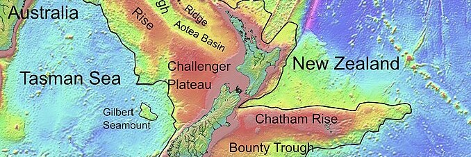
Zealandia
The largest and most notable of these is Zealandia, a submerged continental landmass located off the eastern coast of Australia. 94% of Zealandia is located under the waters of the Pacific Ocean, with the only lands above sea level being New Zealand, New Caledonia, and a few minor islands such as Norfolk Island and Lord Howe Island, both part of the country of Australia. This landmass formed between 83 and 79 million years ago, when it separated from Gondwana, a supercontinent that includes modern-day South America, Africa, Madagascar, Australia, Antarctica, India, and the Arabian Peninsula. Zealandia slowly sank under the ocean, becoming mostly submerged around 23 million years ago.
Zealandia has an area of about 4.900.000 km2, which is around 2/3 of the area of Australia and makes it by far the largest submerged landmass in the world. Due to its size, it has been described as the world’s eighth continent, while according to other experts it is better classified as a microcontinent or a continental fragment.
The submerged continent is divided into a southern portion located on the Pacific Plate and a northern one on the Indo-Australian Plate, with New Zealand at the center. The compression along the border between the two plates formed the Southern Alps and the islands of New Zealand. This area also experiences some volcanism, and forms part of the Ring of Fire that surrounds the Pacific Ocean, although present-day activity is low compared to millions of years ago.
The name Zealandia was coined by American geophysicist and oceanographer Bruce P. Luyendyk in 1995, who proposed a model for the fragmentation of Gondwana that included the submerged landmass off the eastern coast of Australia. The complete mapping of Zealandia was only concluded in 2023.
Topographic map of Zealandia (Ulrich Lange, Wikimedia Commons, CC0 1.0).
Kerguelen Plateau
While Zealandia might be the only submerged landmass large enough to be considered a continent, there are various other lands of notable dimensions hiding beneath the oceans. One example is the Kerguelen Plateau, a large igneous province located on the Antarctic Plate in the Southern Indian Ocean, about halfway between Africa and Australia.
The only lands of the Kerguelen Plateau that are now located above sea level are the Kerguelen Islands, which are part of the French Southern and Antarctic Lands, and the Heard and McDonald Islands, a territory of Australia. All these islands are uninhabited, except for the personnel of the scientific base of Port-aux-Français on Kerguelen Island.
The plateau was formed starting around 130 million years ago with the breakup of Gondwana and the volcanic activity of the Kerguelen hotspot. Limited and intermittent volcanism continues in some areas, such as the Heard and McDonald Islands. The Kerguelen Plateau is one of the largest igneous provinces in the world, with an area of more than 1.200.000 km2, which is more than double than Madagascar, but much smaller than the largest island, Greenland, which has an area of more than 2.100.000 km2. The Kerguelen Plateau has been described as a microcontinent due to its continental origin. It has been estimated that between 100 and 20 million years ago large parts of the plateau were above sea level, before it sunk under the ocean.
Bathymetric map of the Kerguelen Plateau (Redgeographics, Wikimedia Commons, CC BY-SA 4.0).
Other submerged microcontinents
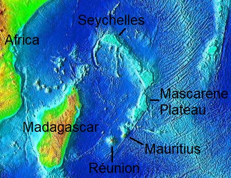
A few other smaller submerged landmasses can be found around the world. After the breakup of Gondwana, the Indian subcontinent separated from Madagascar forming the Mascarene Plateau, the second largest plateau in the Indian Ocean, after the Kerguelen Plateau. The islands above sea level that are part of the Mascarene Plateau are the Seychelles, Mauritius, and the French overseas department of Réunion, along with various other smaller islands. The plateau has an area of 115.000 km2 and is mostly located just between 130 and 8 meters below sea level. During the most recent ice age, the area was likely an archipelago, with some islands being above water as recently as 6.000 years ago.
Two microcontinents have been identified in this area. To the north is the Seychelles microcontinent, which originated about 750 million years ago and separated from India and Madagascar between 95 and 84 million years ago, later sinking under the water. To the south is Mauritia, a microcontinent that was initially attached to India until it separated from it around 60 million years ago. This landmass is now fragmented between various ridges and banks located between India and Madagascar, while the continental crust under the islands of Mauritius and Réunion has been buried under the volcanic material from the Réunion hotspot.
Topographic map of the Mascarene Plateau.
Moving to the northern hemisphere, a submerged section of continental crust is located northeast of Iceland, and it is known as the Jan Mayen microcontinent. The area lies almost at the border between the Eurasian Plate and the North American Plate, and it separated from Greenland. The only part of this microcontinent that is above water now is the island of Jan Mayen, which is part of Norway. However, Jan Mayen is much younger, being formed by the activity of the Jan Mayen volcanic hotspot.
Various other smaller continental fragments are sometimes described as (partly) submerged microcontinents, such as the Azores Plateau located around the Azores Islands in the Atlantic Ocean, and various islands in the Indonesian Archipelago. In addition, there are many more lands that were submerged by rising sea levels after the most recent ice age and are part of the continental shelf of the adjacent continents, so they are not microcontinents.


